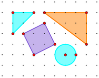
Use a coordinate system to make a Sketchpad geoboard. Objects you construct on this geoboard will always stick to the grid dots; segments look and behave just like rubber bands attached to the posts on a physical geoboard. And with a Sketchpad geoboard you can construct polygons and circles, and you can measure lengths and slopes of segments, perimeters and areas of polygons, and coordinates of points.
1.Choose Edit | Preferences | Units and set Distance Units to cm.
2.Choose Graph | Dotted Grid.
3.Select the grid (by clicking a grid intersection) to change the dot color (by choosing Display | Color) or to change the dot size (by choosing Display | Point Style).
4.Hide the origin, unit point, and axes.
5.Choose Graph | Snap Points to make points snap to the dots.
Your geoboard is ready for use.
When you turn on Snap Points, dragged and newly constructed points snap to integer coordinates. For proper operation of the geoboard, grid dots must also appear at integer coordinates; otherwise points won't snap properly to the grid.
If you adjust the scale by dragging the unit point before hiding it, take care that dots still appear at every integer, rather than at fractions or multiples of integers.
If you adjust the scale after drawing on the geoboard, the points you've constructed won't follow the dots. Drag the points to snap them to dots again.
When you measure length, distance, area, perimeter, and circumference on the geoboard, the results are in cm or cm2. If you change the scale of the geoboard so it's is no longer exactly 1 cm, these measurements will no longer correspond to the dot positions.
Coordinate distance measurements remain correct even with a changed scale.